Searching Archive Imagery
In this section, you will learn how to browse, evaluate, and purchase archive imagery from leading vendors through the platform.
To search and purchase archive imagery, do the following:
| Step | Field | Description | What It Means |
|---|---|---|---|
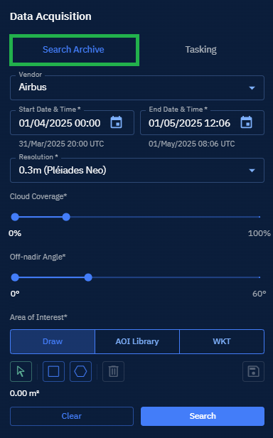
| 1 | Vendor | Select a satellite data provider. | Determines which satellite constellation and imagery products are available; affects pricing, licensing terms, and available technical specifications. |
| 2 | Start and End Date & Time | Set the start and end of the temporal search window. | Defines the earliest acquisition timestamp to include in search results; UTC conversion provided for cross-timezone consistency. |
| 3 | Resolution | Select a spatial resolution of imagery. | Determines the ground sample distance (GSD); affects file size, processing requirements, and minimum feature detection capabilities. |
| 4 | Cloud Coverage | Select maximum acceptable cloud percentage in imagery. | Filters out images with cloud obstruction; lower values ensure clearer imagery but may reduce available options. |
| 5 | Off-nadir Angle | Select maximum acceptable viewing angle from satellite to target. | Controls geometric distortion tolerance; lower values provide more nadir-looking (downward) views with less building lean but fewer available images. |
| 6 | Draw | Select a tool (Rectangle or Polygon) for manually defining the Area of Interest on a map. | Enables interactive rectangle and polygon tool for definition for spatial filtering. The exact geographic extent to be captured; directly impacts collection feasibility and pricing. |
| 7 | AOI Library | Select a pre-saved Area of Interest from the system library. | Provides access to stored spatial definitions for consistent, repeatable queries across projects. The exact geographic extent to be captured; directly impacts collection feasibility and pricing. |
| 7 | WKT | Select to insert Well-Known Text representation of a spatial geometry. | Enables programmatic definition of complex spatial queries using standard geometric notation. The exact geographic extent to be captured; directly impacts collection feasibility and pricing. |
| 8 | Search | Click the Search button to find and purchase archive imagery from leading vendors through the platform. | - |
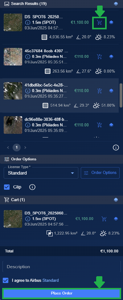
Search results are displayed.
| Step | Field | Description | What It Means |
|---|---|---|---|
| 9 | Add to cart | Click the Add to cart icon of the respective image that you want to purchase. | The platform displays the Order Options dialog box for you to confirm the order. |
| 10 | Place Order | Click the Place Order button to purchase the image. | The platform places the order to the vendor on your behalf. |